
Gunung Lambak
Elevation
510m
Duration
Day Hike
Climbing Season
Best Weather
Jan-Oct
Location
Johor, Malaysia
– Lambak I/North Peak (510m)
– Lambak II/South Peak (460m)
– Main Trail Entrance (Water Park)
– Big Tree Trail Entrance (Chinese Temple)
– Padang Tembak Trail Entrance (Telecom Tower)
– Hospital Trail Entrance (South Peak Exit)
Closest Town
Kluang
Nearest Airport
Johor Bahru Senai International Airport
(1.5hrs away from Kluang)
Tap the links to save them on your google map
Also known as “Flea Mountain” for its modest size compared to the other bigger mountains in Malaysia, Gunung Lambak is a prominent landmark in the quaint town of Kluang. Steep sections, deep tree roots and uneven rocky steps, it is the perfect introduction to Malaysia’s jungle hikes. I was introduced to Lambak by a friend and it easily became one of my favourite training sites for our Mount Kinabalu climb.
With increasing popularity, Lambak has become more developed over the years. The main trail now has landscaped features, clearer signages, and proper steps built in. Thankfully, a separate challenging route retaining some of its rustic charms had remained for people who are there for the rugged experiece. The main peak now also boasts a solid viewing platform complete with a summit marker — major upgrade from the days balancing on a wobbly metal pole for a photo. What many miss is there are actually a number of trails within Lambak that are worth exploring and could add more elevation for training.
The best thing about Lambak: no entrance fee, no permit/guide required, free parking and there is even a basic toilet with shower at the main trail entrance. It is straightforward to reach by car (2hours from Johor Bahru or Singapore) or public transport. Finish the hike and you still have time to wander Kluang town, or just come in, loop the quieter trails for extra work and head home. Lambak guarantees an enjoyable hike for those who are just starting out as well as serious hikers looking for a good session. Read on for trail routes, how to get there and everything else you need to know to plan your Gunung Lambak hike.
Table of Contents
⇾ Exploring Gunung Lambak in 2026: The 4 Hiking Trails, Difficulty & Recommended Routes
⇾ What to Expect on your Gunung Lambak Climb — Terrain, Landmarks, Scenary & Wildlife
⇾ How to Get to Gunung Lambak — Directions, Public Transport & Parking
⇾ Useful Tips for First-Timers — What to Bring, Wayfinding in the Forest & Safety
⇾ Gunung Lambak FAQ — Best Time to Visit, Food, Water Points, Showering Facilities, etc
Exploring Gunung Lambak in 2026: The 4 Hiking Trails, Difficulty & Recommended Routes
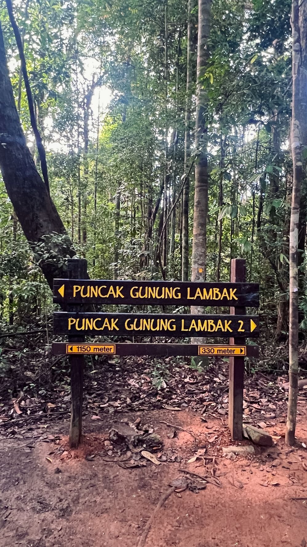
Gunung Lambak has two peaks and four trails — each with its own character. Most visitors hike the main trail to get to the main peak also known as Lambak I/North Peak (510m). The other peak, Lambak II/South Peak (460m) sits not far beyond and is less visited but definitely worth the extra effort.
The four trails fan out from different entrances across the mountain, each with its distinct landmark, and how you combine them determines how much training and intensity you get.
The most accessible starting point is the Main Trail Entrance, located next to a Water Park. You will find plenty of parking, toilets with shower, food and drinks options nearby. The other slightly more remote starting point will be the Big Tree Trail Entrance located within a Chinese Temple.
The remaining other two entrances are rarely used and harder to reach; the trails from these are best hiked from inside and only to their respective landmarks rather than to the end — Telecom Tower/Stesen Microwave on the Padang Tembak Trail, and Lambak II/South Peak on the Hospital Trail.
Below are the trails/routes I traced out using OpenStreetMap and AllTrails:
You can try different combinations of the routes each time you visit to stack up elevation for your training needs. That’s the beauty of Lambak, it never gets boring. Below are some recommended routes:
Route 1: Lambak I via Main Trail (most common)
↪ Water Park > Lambak I > Water Park | ~5km return, ~430m elevation, 2-4hrs
This is the most straightforward and popular route taken by most. You will very likely encounter at least one other hiker on the way.
Enter from the trailhead located just beside the water park. Partway up, past a series of water features, you will see two signed posts on the left: Normal or Challenging. Normal involves steps and roots with a few scrambling sections, manageable for beginners. Challenging is steep, rope-assisted and raw, preserving the older Lambak in its original character — very good training. Both will lead you to summit Lambak I. You can take one route up and switch to the other down to experience both.
On descent, watch for another split after getting down back at the water features area: return the exact way you came, or bear straight onto the Resort Trail — a more gradual, flatter, gravel path that loops around the other side of the water park back to the same trailhead. It will be a lsightly longer way but worth checking out if you are not rushing for time. Along this way, you will pass by boutique guesthouses and cafes that have been quietly taking over what was once an abandoned chalet project.
Beginners or reasonably fit hikers should allow up to 4hrs return. Fitter hikers can comfortably complete under 2hrs.
Route 2: Lambak I via Main Trail-Big Tree Traverse
↪ Water Park <> Lambak I <> Chinese Temple | ~5-6km return, ~370-430m elevation, 2-4hrs
Route 2 is a natural extension of Route 1 that takes you through a second trail out a different exit. Walk towards the resting hut located on the other side of the summit marker and you should see a path leading you downwards on the left. There are no signages so double check the direction or ask around if you are unsure before entering. The Big Tree Trail is named after the landmark giant tree you’ll pass mid-descent and the terrain will be more rooted and forested than the Main Trail.
This route works in either direction. Note that the Chinese Temple entrance/exit is more remote with fewer transport options. More in the section on directions below. My last hike from the Chinese Temple to the Water Park with a group of first-time hikers clocked 370m elevation and took around 3hrs. Fitter hikers can expect to complete in 2-2.5hrs.
Route 3: Lambak I & II via Main Trail
↪ Water Park > Lambak I > Lambak II > Water Park | ~5km return, ~530m elevation, 2-4hrs
Extend your hike a little and include Lambak II in the loop for some added intensity. From Lambak I, the trail toward Lambak II runs flat or gently downhill for about 15min before hitting a 10-15min steep climb that looks harder than it feels once you start moving. After summitting Lambak II, the southern trail brings you back down on an easier descent to the Water Park trailhead. Check your map on the splits to make sure you don’t go the wrong way down to the Hospital Trail.
Lambak II is a satisfying add-on that doesn’t dramatically increase the climb duration but does push the elevation up a notch.
Route 4: Butterfly Loop (most challenging)
↪ Water Park > Lambak I > Telecom Tower / Stesen Microwave > Big Tree > Lambak I > Lambak II > Water Park | ~10-12km, 800m+ elevation, 4-6hrs
Named for the butterfly shape it traces on a GPS tracker, this is the full circuit covering every landmark on the mountain. You will summit Lambak I twice from opposite directions, hike through the rugged patch between Telecom Tower and Big Tree, and push up to Lambak II before finishing. Variations exist and you can plan the way you wish to complete it. The route above is the recommended option.
Thorough, challenging and really rewarding. Lambak’s Butterfly Loop is for experienced/prepared hikers who are looking for a serious training session. Plan for at least 5-6hrs. Even at strong pace, expect no less than 4hrs.
What to Expect — Terrain, Landmarks, Scenary & Wildlife
Terrain
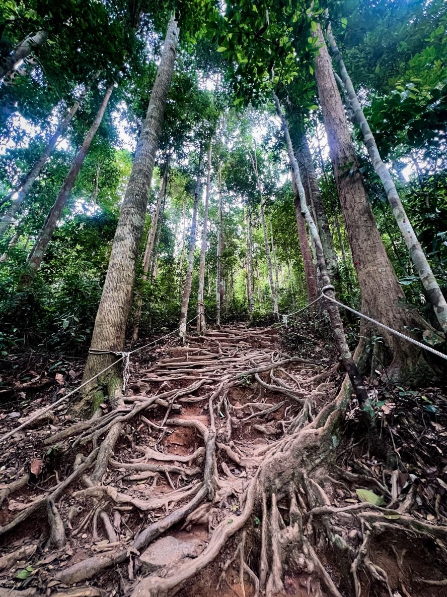
This is a Malaysian jungle hike in the truest sense. Natural trail paths, thick tree roots, rocky steps, muddy patches after rain, dense humid conditions. No technical climbing skills or specialist gear is required, just a good pair of shoes, light clothing and a reasonable level of fitness.
The terrain at Gunung Lambak is largely consistent across all four trails. The one exception is the Challenging route on the Main Trail which is steeper, more demanding and trickier with some scrambling sections. In recent years, more steps have been built in and additional support ropes have been installed, making it more navigable.
Landmarks & Scenary
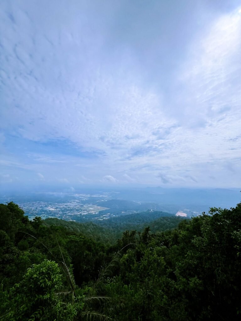
Main Trail starts from the Water Park and winds past small water streams before the climb up to summit Lambak I. Lambak I is the only spot on the whole gunung that gives you a nice view overlooking Kluang town below. That is also the reason why most people end their hike here.
Lambak II is less visited, marked simply by a bench and a signage at the peak. If you exit Lambak II rather than looping back on the Southern Trail or back to Lambak I, you’ll be on the Hospital Trail — a long path that eventually leads to the middle of a road junction. It is not recommended to go out that way.
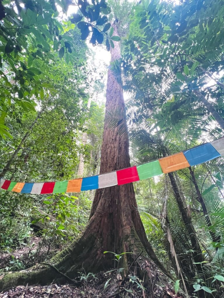
Big Tree Trail is named after one of the most enormous trees, literally ‘Big Tree‘, lining the path. Some of these trees have prayer flags on them and the forest grows quieter the further in you go. The trail starts/end at a peaceful Chinese Temple situated nearby Talula Hill with farmstays and small resorts tucked in the surrounding area.
Padang Tembak Trail leads to/from a Telecom Tower built in the 1960s. The satellite dish sitting outside the compound, locally known as Stesen Microwave, has quietly become a photo spot and milestone for hikers completing the trail. A connecting path links the Tower directly to the Big Tree landmark, forming the outer stretch that makes the Lambak Butterfly Loop.
Wildlife
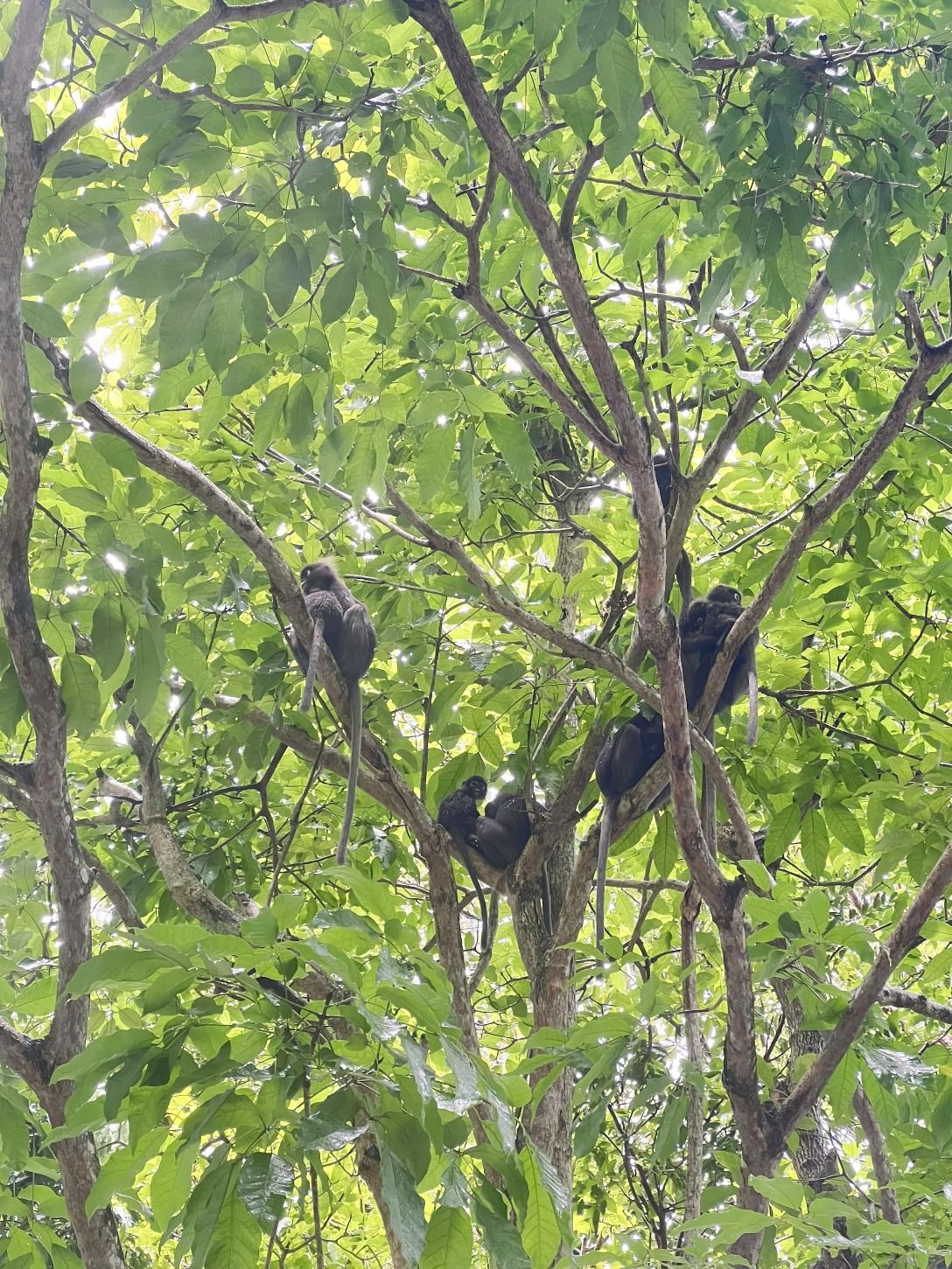
Gunung Lambak has a healthy range of wildlife and a diverse species of butterflies with many common sightings. The long-tailed macaques and pig-tailed macaques appear regularly, sometimes right at the water park parking area. Dusky leaf monkeys move through the canopy above the trails, and plantain squirrels and giant black squirrels are frequent company.
A variety of tree snakes and interestering birds are around too — well documented by birders with a full list logged on eBird. A few were even lucky enough to see the Rhinoceros Hornbills. I have yet to spot any. Keep a look out for them as you go about your hike!
How to Get to Gunung Lambak — Directions, Public Transport & Parking
By Car
The easiest way to get here is by the Water Park entrance. Plug in Gunung Lambak Entrance on Google Maps or Waze and it should take you to Jalan Kampung Masjid. As you near your destination, you will see signages to turn left into the Water Park. Ignore that and continue straight towards the bend until you will see the Gunung Lambak Entrance Arch. There are ample parking along the whole stretch of road near the entrance and parking is free. If it’s a busy morning, just follow what the locals do. Don’t be surprised to see cars lined up on the grass verge. Very Malaysian, very normal. Just don’t block the road and you’ll be fine.
To get to the Chinese Temple entrance, plug in Gunung Lambak Temple on the navigation. It is near Kefi Farm Cafe. You will hit some rocky, bumpy roads once you turn in from Jalan Padang Tembak and pass by a few eco farm/resort. If you’re driving and plan to do a one-way Main Trail–Big Tree Traverse, note that starting from the Chinese Temple and ending at the Water Park might be better — Grab pickups from the Chinese Temple end are harder to arrange. More on that below.
By Public Transport
Entirely doable. Head to Kluang town then take a Grab to Gunung Lambak Entrance from whereever you are. This takes you to the Main Trail entrance near the Water Park. It should cost less than MYR 10 and take about 10min if you’re coming from Kluang Bus Terminal. Same for return, you will be able to book a Grab easily from this entrance to the next location you plan to go.
If you plan to exit at the Chinese Temple, factor in that Grab availability at that end is limited and less reliable. Aim to finish before 5pm. If you can’t get a pickup, Kefi Farm Cafe under Talula Hill Resort nearby may be able to arrange a driver though this may come at an additional charge. To keep things simple, starting from the Chinese Temple (Big Tree Trail) and exiting the Water Park (Main Trail) is the more practical direction if you wish to attempt the traverse one-way.
To start from the Big Tree Trail, you can grab to Gunung Lambak Temple. Booking a grab from Kluang Bus Terminal to the temple should cost no more than MYR 12 and take around 15min.
The other two entrances — Padang Tembak Trail (Telecom Tower) and Hospital Trail — are not recommended as starting or ending points. No parking, no reliable pickup, and too remote to make logistics work.
Useful Tips for First-Timers — What to Bring, Wayfinding in the Forest & Safety
What to Bring
Malaysian jungle means heat and humidity, typically between 24–35°C, and you will sweat through whatever you’re wearing. Wear light, breathable clothing, solid sun protection, and mosquito repellent. It is a mosquito haven. A light rain jacket or poncho would save you from afternoon downpours that can be quite common as well. Ziplock your valuables. It gets very wet and muddy when it rains.
Shoes matter. Plenty of hikers show up in running shoes, sneakers, or even sandals and make it work but grip becomes important quickly on the steep sections and wet roots. Shoes with good grip will make the hike more manageable and enjoyable.
There are no food or water points on the trail so bring whatever you need. A typical hiker will need about 1 litre of water for the 3-4hrs hike via the Main Trail. I managed with less than 500ml as someone who can survive a 21km run at 24°C without water. Not healthy nor recommended, just a benchmark for you to gauge your needs. Bring more water and some snacks for energy if you’re planning for an extended hike and especially if you plan to attempt the Butterfly Loop. More is better than less, but balance the weight.
If you’re planning to shower after, pack toiletries, a light towel, and change of clothes. A hook/carabiner and a shower bag will come in handy. You can leave it in the car if you’re driving — the toilet is right infront of the carpark at the Main Trail trailhead.
Wayfinding & Safety
The Main Trail and connecting routes between Lambak I and Lambak II are well-signed and hard to miss. On weekends, you’ll rarely be far from another hiker to ask for directions.
For the other three — Big Tree, Padang Tembak, and Hospital Trails — download the AllTrails app before you leave. Search for Gunung Lambak Recreational Forest and save the map offline. Mobile signal gets patchy and drops out on deeper sections of the trails. AllTrails is widely used by Malaysian hikers and the Lambak routes have been accurate and up to date so far. If it is your first time, try to go with at least one other person and aim for a weekend when there’s a better chance of crossing paths with other hikers.
Some basic safety habits that I keep to regardless of how familiar I am with the trail. For any jungle hikes, make sure your phone is fully charged and bring a portable charger. Also, bring a whistle, first aid and any personal medication along. When I trek solo in unfamiliar countries, I also make sure I get a reliable mobile line with sufficient calling credits that will allow me to make calls in case of emergencies.
If you’d rather not handle the logistics yourself, there are organised day tours from Singapore that cover the hike, transport, meals, and usually a stop in Kluang or a shopping detour through Johor Bahru on the way back. These are options you can consider too, though expect to pay SGD100+ per person. You can find them on Meetup and/or Facebook.
Gunung Lambak FAQ — Best Time to Visit, Food, Water Points, Showering Facilities, etc
What is the Best Month to Visit Gunung Lambak?
Any month works but avoid the monsoon season from Nov-Dec. There may be occasional flooding in Kluang at times too that can cause the park to close temporarily so check out the news before going.
Outside of that, even if you catch some rain, hiking is still manageable as long as it’s not a heavy downpour — just expect muddy, slippery conditions and take extra care at the steeper sections.
What Time should I Start the Hike?
Any time before sunset — there’s no lighting once it gets dark. Morning is the most popular start time and the coolest of the day. Afternoon works too as the forest is mostly shaded. Humidity stays high regardless of when you go so just ensure you bring adequate hydration.
Plan your start time around how long your chosen route takes and whether you want time to explore Kluang town after.
Can I hike Gunung Lambak solo?
Yes. The main trail is well-signed and straightforward for trekking solo. However, for the less frequented trails, it is worth going with at least one other person and stick to weekends when more hikers are around. See the navigation and safety section above.
Do I need permit or guide to Hike gunung Lambak?
No permit or guide required. The main trail is also clearly marked and easy to follow independently. For the other trails, the AllTrails app would be handy. See the navigation and safety section above.
How much does it cost to Hike gunung Lambak?
$0! No entrance fees, no permit costs, free parking at the trailhead. The only costs are however you choose to get there.
If you’re joining an organised tour from Singapore, expect to pay SGD 100+ per pax which covers transport, the hike, meals and stops along the way. DIY and you can do so much more with the same/lesser budget.
Are there any water points on the Trails at Gunung Lambak?
No water points anywhere on the mountain. Bring your own and bring enough. The humidity here is serious and you’ll go through more than you expect.
Bring a minimum of 1 litre for the main trail and more for longer routes. See what to bring above.
Are there any shops or Food Stalls at Gunung Lambak?
Not on the trails. Bring your own water, snacks and whatever you need in the forest. See what to bring above.
There are usually 1-2 small makeshift stalls at the Water Park trailhead selling drinks, fruits and local snacks with their memorable Tiger plush toys. In recent years, a handful of cafes have also opened up around the Water Park and there is one Hill and Heal Cafe 10min into the trailhead gaining much popularity. Most only operate on weekends.
Are there Toilets or Showering Facilities at Gunung Lambak?
At the Main Trail entrance, there is a very basic toilet block with 4 cubicles in total, split evenly between male and female. One squat toilet and one sitting toilet each side. Cold mountain water, pipes and buckets are available in all cubicles for those who want a quick shower. Bring your own shower bag and a hook/carabiner will come in handy. This is free and most hikers make do. Alternatively, the Water Park charges MYR5-7 for entry to use their facilities.
No toilets or showers on other parts of the trail on Gunung Lambak or at any of the other entrances.
What is the temperature at Gunung Lambak like? What Should I wear for the hike?
Temperatures sit between 24–35°C. Wear light, breathable clothing for the heat and humidity.
Cover your arms and legs where you can as it helps against mosquitoes and protects your skin on the rootier, rockier sections. Sun protection and insect repellent are both essential.
Do I need Gloves or hiking poles to Climb Gunung Lambak?
Neither is required. The trail does not involve technical climbing and most hikers complete it without either.
That said, poles can help on steep descents if you’re used to hiking with them and lightweight gloves may give extra grip and knuckle protection on the rope sections of the Challenging route.
Having good shoes is more important.
Can I get to Gunung Lambak by Grab?
Yes. Grab works well to and from the Water Park trailhead. If you’re planning to exit at the Chinese Temple instead, availability is more limited. See the directions section above for the full breakdown.
Have questions that aren’t covered here, or updates and experiences you’d like to share? Feel free to reach out and I’ll get back to you as soon as I can.